Accessibility Improvements, Monument Relocation Coming to Veterans Memorial Park
Andrew Trzaska | August 13, 2013
After a year of behind-the-scenes work, representatives planning a improvements to the Veterans Memorial Park between Muskegon and North Muskegon showed off their plans to make the 28-acre site more accessible and accommodating for events at Muskegon’s city commission meeting Tuesday.
The project is expected to cost just short of $1 million, with MDOT footing a $960,000 of the bill. Muskegon and North Muskegon will put in approximately $35,000 in matching funds. Local veterans groups, the Lions club, MDOT, the cities of North Muskegon all will be involved in the project design and construction of the project alongside Muskegon.
Tuesday’s presentation was a requirement to receive the MDOT grant dollars, which the project has been awarded. The City of Muskegon already passed a vote several months ago on its part of the match dollars, so the project is set to proceed pending approval from all governmental bodies that have a say.
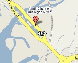
The park can be found at Muskegon’s northeast end, on the riverbed of the north branch of the Muskegon River by the B.C. Cobb power plant. The Veterans Memorial Park is the primary connector between North Muskegon and the Moses J. Jones parkway, which runs between the Jackson Hill and Nelson Neighborhoods from downtown.
The river drains into the east end of Muskegon Lake near the park, and is frequently used by residents for fishing, walking, jogging, remembrance events and bird watching.
Currently, there are many areas in the park that are not “barrier free,” meaning people with disabilities may not be able to get around in without difficulty. Barrier free improvements will be made across the park. Sidewalks will also be extended from the south end of the park all the way to the north end, where there currently aren’t any. A new parking lot will be put on the north end of the park, and existing parking lots will be improved. New streetlights matching those seen downtown will be added along the roads on either side.
All of these improvements are working toward the site handling more events in the future. Right now, ceremonies are held in a small area at the south end that is not barrier-free, and is a half-mile from the north end, where a monument showing the five flags of the five U.S. armed services is located. A new ceremonial area will be located on the north end, which will have two tiers for events to set up on. Some of the monuments on the north end that are currently inaccessible by foot will be moved around the site as well. This includes an obelisk found at the very north tip of the park, which was deemed a road hazard by MDOT.
Hooker DeJong is the architect of record on the project. Frank Bednarek from the firm spoke at Tuesday’s meeting on the complexity of making the improvements.
“The project looks simple on the surface, but it’s not,” said Bednarek. He explained that since the entire park is on a flood plan, the Michigan Department of Natural Resources has jurisdiction over the projects. The Army Corps of Engineers must approve the plan because the Muskegon River is a navigable channel. Furthermore, two divisions of MDOT must approve it, as must the cities of Muskegon and North Muskegon. On top of it all, the engineers are working Consumers Energy is changing street lighting.
The group behind the improvements will continue their design and planning stages until they get all of the required approvals. A start date for construction is planned for 2014.


